Tuesday, June 30, 2020

Kayaking the Waccamaw River from J Todd Landing

  • Date Kayaked: May 18, 2020
  • Total miles Tracked: 4.68 miles 
  • Type of Trail: River
  • Best Features: Wildlife, very peaceful, calm current
  • Worst Features: No facilities at landing
  • Wildlife spotted: Osprey, woodpecker, alligators, turtles
  • Vegetation: Cypress and hardwoods, wildflowers
  • Associated Website:https://www.horrycounty.org/Departments/ParksAndRecreation/Boating (Note: This is the official site, but good luck finding a mention of this location!)
  • Primary Author:  James

Back in May, we took a long weekend to kayak in South Carolina. We launched from three different boat ramps on the Waccamaw, plus kayaked in the Marsh at Murrells Inlet. We were down on the weekend when South Carolina was loosening some of their Covid 19 restrictions. This created some stressful, crowded conditions on some of the waterways we tried out. But, our final destination before we left the state was J. Todd Landing just outside of Conway. It was like a completely different river! We kayaked almost 5 miles and saw only two motorboats. 


The landing itself is rather barebones. You drive down Jackson Bluff Road until you reach a sandy parking lot. There's no boat ramp, just a beach of firm sand, perfect for kayak launches. There are a few private residences adjacent to the ramp, but this is located in the Waccamaw National Wildlife Refuge, so for the most part you'll be leaving civilization behind once you're in the water. 


For the most part... there is a curious rusting artifact downriver from the launch. What it might have once been is a mystery to us. 

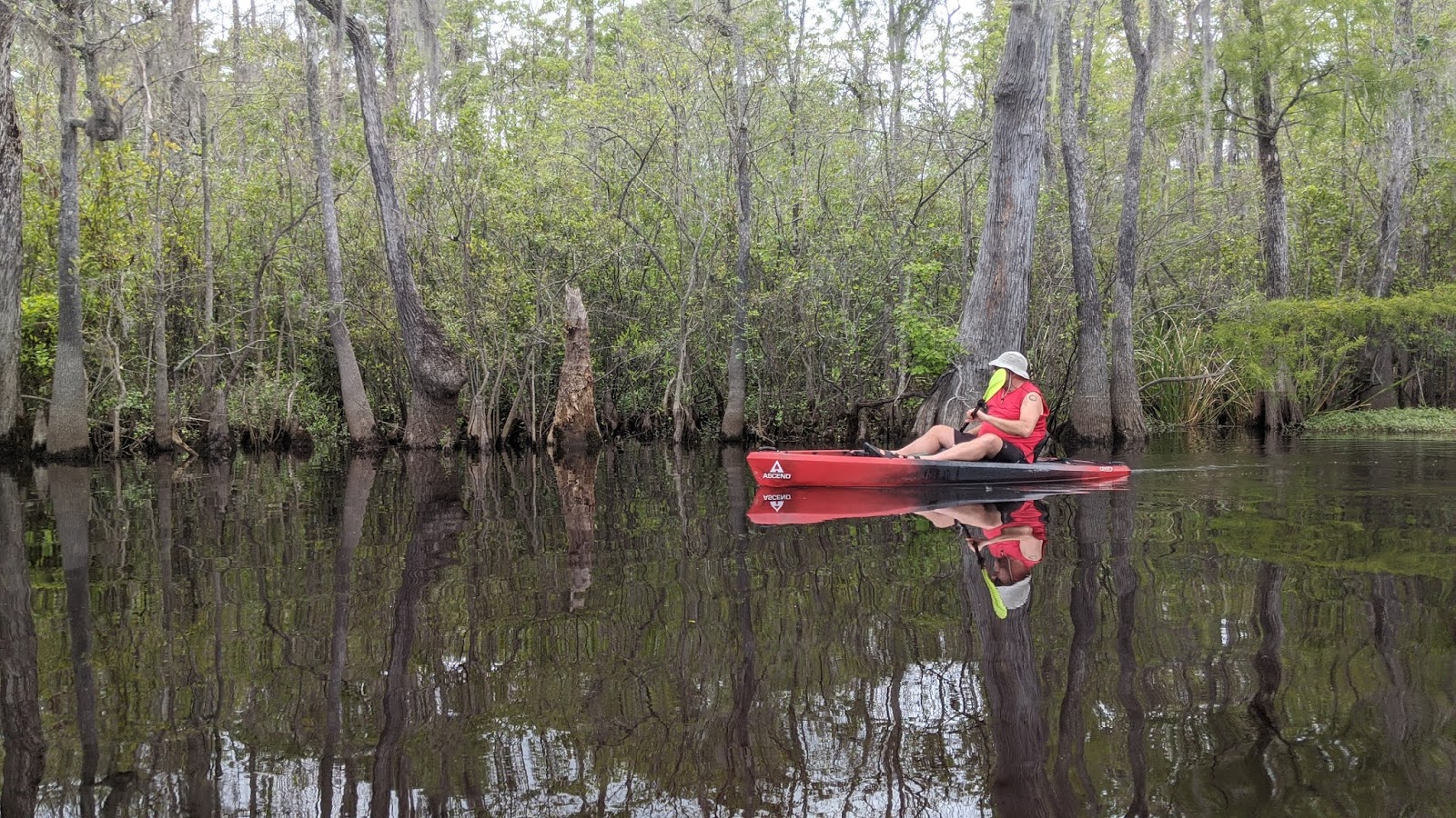
Once you're past this, however, you're entering undeveloped land along both sides of the river. You're several miles from the nearest ramp where motorboats launch, and far from any road, so it's one of the quietest places we've kayaked. The lack of noise meant that wildlife was easy to spot along the river. Turtles, osprey, woodpeckers, and alligators! We spotted five alligators during this paddle, after seeing none on our previous Waccamaw trips. 


One big advantage of launching from J Todd Landing is that you're launching next to Thorofare Island. You can go downstream on the Waccamaw, then back upstream on Thorofare Creek to have a nice loop trail. Going upsteam on the creek was no challenge. For the most part, the water on the both the river and the creek is wide and deep and still as you glide along past cypress trees. There are oxbows and side creeks to explore if you have time. 


Overall, this has shot to the top of our favorite places to paddle in South Carolina. It's got a great combination of ease of access, wildlife, paddling conditions, and a loop route that's long enough to be worth the journey, but not so long it turns into a slog. This is one of those places we almost hesitate to write about, since isolation and emptiness is part of it's charm. Hopefully we won't see you out there!


Monday, June 15, 2020

Biking the Lynchburg VA Trail system

  • Date Biked: May 2, 2020
  • Total miles Tracked: 19.85 miles 
  • Type of Trail: Greenway
  • Best Features: Long trail road tunnels and bridges
  • Worst Features: Creekside trail is very rugged
  • Wildlife spotted: None
  • Vegetation: Pines and hardwoods, wildflowers
  • Associated Website:https://www.lynchburgparksandrec.com/trails/
  • Primary Author:  James

They Lynchburg greenway and rail trail system doesn't pop up if you're googling for long greenways, which is a shame, and something of a branding problem. Lynchburg's trail system is mostly interconnected and cumulatively adds up to permit 20 miles + of biking without ever once needing to ride on a road. But, rather than advertise it as one big trail, it gets promoted as a bunch of little trails: The Riverwalk Trail, the Blackwater Creek Trail, the Kemper Station Trail, and the Point of Honor Trail. There's also several unpaved mountain bike trails connecting to this, including the Creekside Trail, which has a very rough and rocky access but then flattens out into a fairly nice ride. If you're like us, you might not be motivated to load up your bikes and drive two hours to ride the three mile long Blackwater Creek Trail, or even the 6.5 mile Riverwalk. Once you discover that these are really one long greenway, the destination becomes more tempting. 


You should give in to that temptation! First, downtown Lynchburg is near the hub of three of the trails, and it's a wonderful, walkable historic area, with plenty of restaurants catering to people who've come downtown for recreation. It's a very nice blend of the old and the new, and Lynchburg gets high marks as a town that seems to really appreciate the users of its greenways. 


Another nice feature of the rail trail segments of the trail system is that Lynchburg is still very much an active railroad hub. You'll almost definitely encounter trains if you're in the area for any length of time at all. And, the rail trail makes use of some fantastic relics from it's previous life, including the Hollins Mill Tunnel on the Blackwater trail and a big trestle bridge on the Riverwalk at the end of Percival's Island.  


There are numerous trail access points, but the best two we've found are the Awareness Garden at mile 0 of the Blackwater Creek Trail, which has bathrooms and a water fountain, and the downtown parking for Percival's Island, which you'll recognize by Lynchburg's "LOVE" sign. No bathrooms or water here, alas, but it does give you easy access to the part of the trail that runs downtown. 


The trails do have a few challenges. The Kemper Station Trail is short, but a real work out, pretty much a continuous uphill grade, though it is fun to zip back down. We didn't ride the full length of the Creekside Trail because it was very muddy, probably because, you know, it's beside a creek, and it was spring time, and there was evidence that parts of this trail are probably underwater for parts of the year. Speaking of being underwater, the Point of Honor Trail crosses a spillway just beneath a dam. We wound up walking our bikes across because the water looked pretty swift, though in retrospect riding through it wouldn't have been any particular challenge. Even if you don't get wet here, prepare to be dripped on in the Hollins Mill Tunnel, which was pretty wet the day we visited. I imagine as we move deeper into summer the trail system will be dryer,


One final recommendation of the trail system is that it's got a nice variety to it. On Percival Island, the trail is flat and straight and rolling through forest and fields, while the Blackwater segment is full of deep railroad cuts, the tunnel, and is generally steeper. I'm hard pressed to think of another trail that packs in such a wealth of different scenes into so few miles. 


The LOVE sign on the Riverwalk features bike wheels, boot prints, kayak paddles and skate wheels. It pretty well sums up our feelings about this trail. It's just a lovely place to spend a day engaging in one or more these activities. 

Sunday, June 14, 2020

Hike in Uhwarrie Forrest - Jumping off Rock trailhead


  • Date Hiked: April 18, 2020
  • Posted length: 20 miles
  • Total miles Tracked: 5.9 miles
  • Type of Trail: Single track trail (moderate)
  • Conveniences: Parking lot
  • Best Features:  For us, this trail is close to where James' sisters live and we enjoy hiking with them.  The trail itself offers varied terrain and it's really beautiful in the Uhwarrie
  • Worst Features:  Jumping off Rock is not on the trail. No bathrooms or water.  
  • Wildlife spotted: Anole
  • Vegetation: Hardwood forest, Mountain Laurel, mosses and fungi
  • Associated Website: https://www.fs.usda.gov/recarea/nfsnc/recreation/hiking/recarea/?recid=49832&actid=50
  • Primary Author: Cheryl


In April, James and I joined his sister Joy and Gina for a hike in the Uhwarrie Forrest in Troy, NC.  We went to the Jumping off Rock Trail head and tackled a section of the Uhwarrie National Recreational Trail.  The main trail itself is 20 miles long, but we chose to park at one of the three trail heads shown on the official website and see how much we could hike in the time we had allowed that afternoon.


There is a really nice parking lot at the Trail end off of Flint Hill Road, more commonly known as the Jumping Off Rock trail head.  We parked and headed over to the posted map at the kiosk.  No real paper maps or downloadable maps seem to be available, so we snapped a photo of the map then proceeded to the trail.  The first section is a very steep climb and is also very rocky.  You quickly climb up 400 feet within the first mile. The trail was lined with Mountain Laurel just beginning to bloom along with every type of moss that grows.


The section we hiked then reaches it highest point and there is a large outcropping of rocks.  We stopped here for a break before heading on along the ridge.  We continued until we reached the crossing of Tower Road before we turned around.  We'd have to come back another day to continue exploring the trail.


There are several campsites with fire rings.
But where was the Jumping off Rock?  Interestingly, it's not on the trail at all.


After we returned to the parking lot, we found out that the rock that the trail head is named for is actually about a quarter mile up Flint Hill Road.  We headed up the hill walking on the road, crossed two bridges and came to rocks that overlooks Barnes Creek.  There are maybe two parking spaces off the side of the road at this outcrop of rocks.  The upper section is covered with graffiti, and there is a trail that takes you down to the creek on one side.  On the other side of the plateau, you can scramble down to the actual "Jumping Off Rock."  Despite the name, jumping off Jumping Off Rock would be a very bad idea.  The creek that is far below is shallow and full of.... you guessed it, ROCKS!

The section of the Recreational Trail we tackled was very pretty, and we look forward to trekking more of it.