Showing posts with label Board Walks. Show all posts

Wednesday, December 15, 2021

Biking the Virginia Capital Trail from Williamsburg to Richmond

  • Date Biked:  September 20 , 2021 (with some photos from a ride in 2019)
  • Posted Mileage : 51.7 miles
  • Total miles Tracked: 53.19 miles
  • Type of Trail: Greenway, paved
  • Conveniences:  Picnic tables, plenty of parking at some trailheads
  • Best Features:   A high quality trail with a great length through multiple historic settings
  • Worst Features: Seldom far from traffic, very few public restrooms or water fountains
  • Wildlife spotted:  Deer
  • Vegetation: Hardwoods, pine, wildflowers
  • Associated Website:  https://www.virginiacapitaltrail.org/
  • Primary Author: James
If you enjoy reading plaques, have we got a trail for you!

Winding over 50 miles from Williamsburg to Richmond, the Virginia Capital Trail is a great destination trip for any biker. For experienced bikers, it's long enough to really test your endurance without dealing with too much traffic. The list of paved trails where you can do a century ride as an out and back and still have some miles to spare is a pretty short list! 

Mile 0.0

Not that we've tackled this as a century ride! There's no shuttle, but we had a friend of a friend ferry us down to Williamsburg after we left our vehicle at Shiplock Park in Richmond. We were dropped off in the parking lot of the Jamestown settlement. We were there before the visitor center opened, but have popped in before and it's a nice place to take a break, especially on a hot summer day. 

Since jets of water are shooting up among the sails, I assume this is some sort of monument to sinking ships. I probably should have read the plaque.

The ride out of Jamestown is very flat. There are a lot of historical markers, and the scenery is a mix of agricultural fields, wetlands, and residential areas. The first few miles have quite a few road crossings. Of note in this segment is Spoke & Art, a bike friendly coffee and treats place with exterior restrooms that are open even when the business is closed. 

Swamps are best viewed in the morning, before the mosquitos have their coffee. 


A few miles beyond this is the Chickahominy Riverfront Park and a semi-steep hill to climb on the arched bridge over the river, but the view at the top is worth the extra sweat. Once you're over the bridge, you pass through a lot of pine forest until you reach Charles City, which is around the 20 mile mark. Here you find another bike friendly restaurant, Cul's Courthouse Grill. They keep a thermos on the front porch for refilling water bottles, and after twenty miles of biking, you can eat a plate of fries mostly guilt free. 

There's an East Coast Greenway sign in the window, so you're technically haven't left the trail if you go inside Cul's for a beer. 


An important note: The trail kind of disappears in Charles City. It's not a huge problem if you are looking at the trail map on your phone, but could benefit from an extra sign or two to let you know you're on the right path while you're following the road through town. 

Right about here, they need a sign saying, "Keep going! You aren't lost!"

Though, seriously, they have great signs all along the trail with distances to upcoming destinations. More trails should make use of these!

Past Charles City is a lot of open farmlands. It's nice scenery, but during hot days there are stretches of several miles without even a hint of shade. Our ride in September was comfortable, but we rode this during July in 2019 and riding these shadeless miles was brutal. There's also pretty much nothing in the way of a water fountain or bathroom for twenty miles once you leave Charles City until you reach the outer edges of Richmond. Finally, after the flat, flat, flat of the Jamestown to Charles City segment, the rest of the trail is kind of hilly. Not mountainous by any means, but more of a workout. The trade-off is that the hilliest sections are also the shadiest sections,  

The VCT imitating Kansas.

You know Richmond is near when you reach the Four Mile Creek trailhead. Tons of parking, but no bathrooms or water. There's a convenience store across the highway, but if you press further along the trail toward Richmond you'll find stores on the trail side of the road. There's also signs pointing to a park with restrooms and water, but we've never detoured to check it out. After veering to avoid an interstate loop, the trail comes back to Hwy 5. Traffic is heavy here, so watch for cars as you come to intersections and parking lots. Eventually, the trail crosses the road. Once you make the crossing, the rest of the ride goes by quickly. The Richmond skyline appears on the horizon and keeps growing. Before you know it, you're riding next to the James River past condos and bars. 

You can tell it's a safe trail since this bike doesn't have a lock and no one has stolen it.

Then, boom, suddenly there's a city.

Shiplock Park is the site of an old canal lock, and the whole area feels steeped in Richmond's industrial past. Railroads pass overhead, there's enormous brick smokestacks, and if you press on to the end of the trail the confluence of interstate, elevated railroad, and massive floodwalls surrounding you feels like an enormous sculpture. 

Railroad, interstate, canal, bike trail. If an airplane is flying over, you've got yourself a transportation museum.


Once you're downtown Richmond, your options for dining or grabbing a drink are too numerous to list. We wound up in a bar in an old fire station that served fried moon pies, to be sure we negated any health benefits we might have gained by biking 50+ miles. 


Jamestown, Charles City, and Richmond combine to make this a very user-friendly trail. Whichever end you bike toward, there's a place to grab a bite to eat and a frosty beverage within walking distance of the final milepost. 

There are more trails beyond this sign as you enter the canal walkways, but that may be a future post. 

The few downsides to the trail would be that it's seldom far from Hwy 5, so expect some road noise and the occasional truck exhaust. While careful planning is important no matter where or when you ride, the exposed nature of sections of this trail means you shouldn't skimp on bringing water. Finally, unlike a lot of long trails, this isn't a rail trail. While much of the terrain is flat, the trail follows the natural contours of the land, so you do hit a few relatively steep hills. 


All in all, this is a great destination, either to tackle all in one hard push, or to explore in multiple segments, or add in as an activity while vacationing in the area. Get it on your travel schedule! 


Thursday, December 24, 2020

Biking Fripp Island and Hunting Island State Park, SC


  • Dates Biked: October 15 and 18, 2020
  • Total miles tracked:  Hunting Island:  14 miles (includes from our rental on Fripp and back), Fripp Island:  11.2 miles.  Beach ride on Fripp:  10 miles.  
  • Best Features: Biking with friends and beach rides! 
  • Worst Features:  Mosquitoes  
  • Wildlife spotted: Egrets, herons
  • Vegetation: Maritime forests, marshes
  • Associated Websites:  pledgethepink.com; https://southcarolinaparks.com/hunting-island; https://frippislandresort.com
  • Primary Author: Cheryl


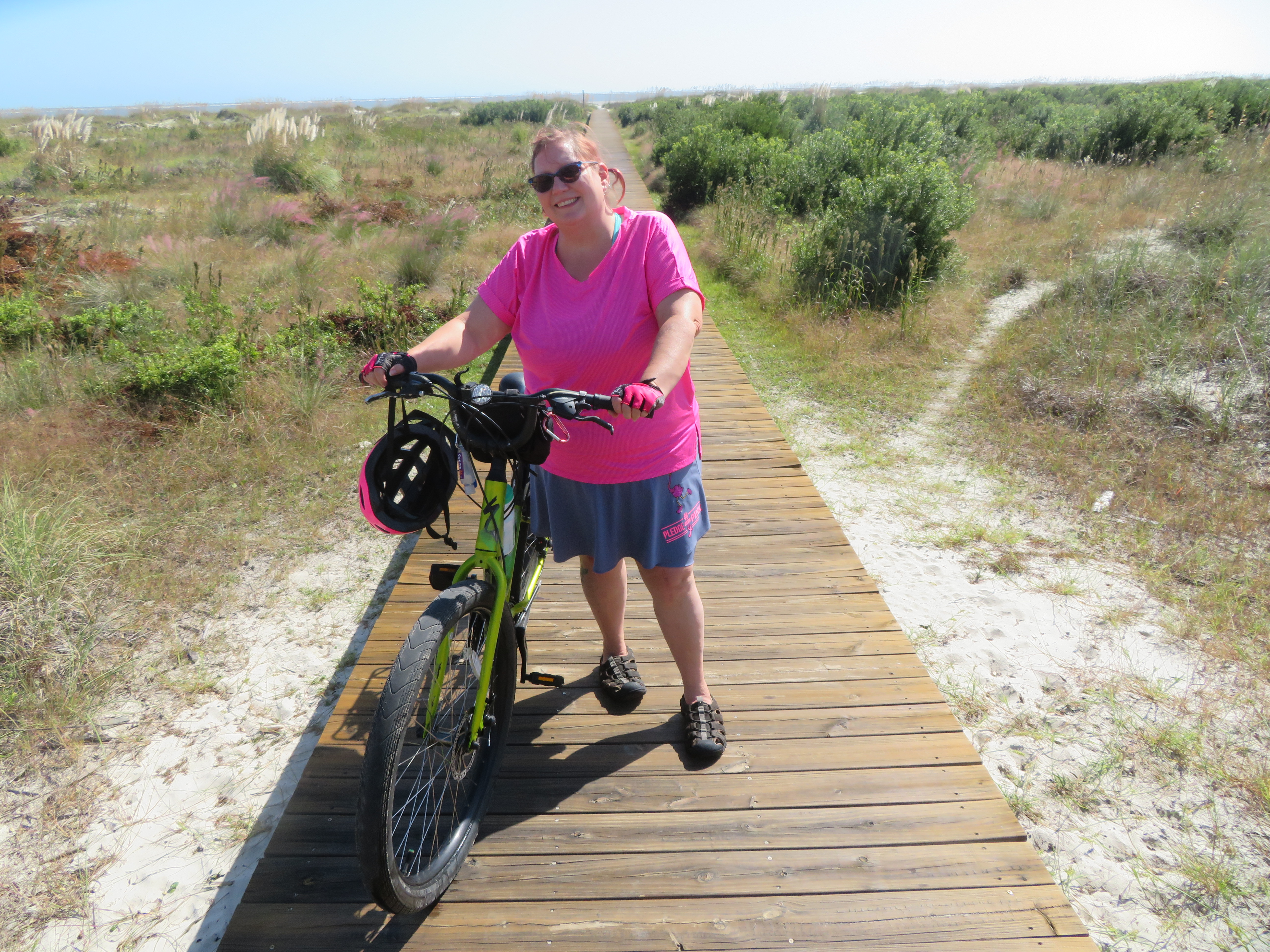
For the last several years, I have been participating in a 3-day walk for Breast Cancer called Pledge the Pink, held in the low country of South Carolina.  This year, it was going to be located with Fripp Island as the home base, with walks on Hunting Island State Park and the Habersham community in Beaufort County.  Alas - Covid.  The walk itself became a virtual event this year, but James and I and our friends Hope and Danny decided to keep our reservations at our house on Fripp Island.  We participated in the virtual event, but chose to get our daily miles on our bikes instead.  We have two other posts for our biking on the Spanish Moss Trail in Beaufort and Pinckney Island Wildlife Refuge in Hilton Head, but we had other great biking on Fripp Island, including their wide beaches and the neighboring Hunting Island State Park, so we felt we needed to share the rides with our readers.  

Hunting Island State Park is just magical.  In addition to the miles of beach that are part of the park, there are 3 main trails that run parallel through the park, and some shorter loop and connector trails, along with the paved roads that wind through the park. Most trails are sandy, so if you're biking, you'll need some wider tires.  There are also roots, fallen limbs and pine cones.

The Lagoon Trail

Leaving the Nature Center parking lot

And did I mention the mosquitoes?  Oh my!  We were there in October and they were the size of pterodactyls!  We had bug spay, but they were biting trough our shirts.  We quickly detoured over to their boneyard beach.  We left out bikes near the footbridge that crosses the lagoon and wandered among the driftwood.   


If you've never experienced a boneyard beach, Hunting Island State Park provides the easiest opportunity to do so.  It's not even a mile from the parking lot at the nature center.  Other such boneyards require ferry rides or several miles of trekking to get there.  And just what is a boneyard beach?  It's where a maritime forest is being reclaimed by the ocean.  

Footbridge to the boneyard as seen from the beach

After wandering around this section of the beach for a while, we hopped back on our bikes and rode up to the lighthouse.  The four of us had climbed the 167 steps of the lighthouse 2 years prior.  With Covid, they were limiting the people climbing the day we here here this year.  If you get a chance to do it, the view is spectacular.  

Hunting Island Lighthouse

We left the main grounds of the state park and headed back down the stretch of HWY 21 back to Fripp Island.  We took a quick detour on the Marsh boardwalk trail.  We were hoping to see some birds, but just saw a bunch of crabs instead.  


We rode our bikes the next two days on the Spanish Moss Trail in Beaufort and Pinckney Island Wildlife Preserve in Hilton Head.  The link will take you to our Spanish Moss review, and Pinkney is coming up soon!

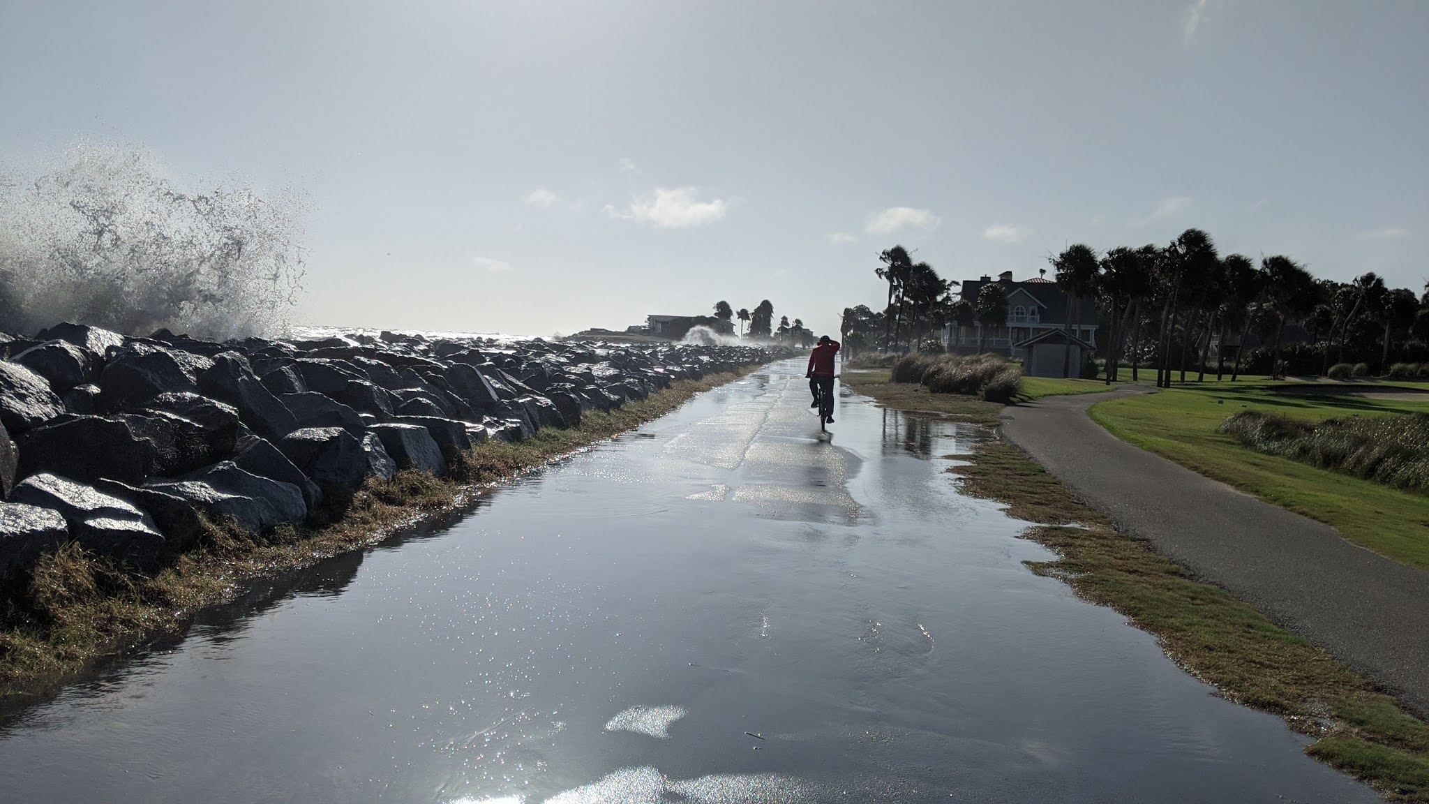
Our last full day at Fripp for Pledge the Pink, we decided to just ride our bikes around the island.  It was high tide and many of the roads on the island were covered in overwash.  That didn't stop us from having some fun.  


SPLASH!

If you can still see the tops of grass, it's shallow enough to ride through!


After lunch, James and I took our bikes over to the beach and rode the entire length of Fripp Island and back.  We love riding on the beach, and the wide stretches of sand during the low tide did not disappoint.  


The pics might make it look like we had the beach all to ourselves. Not true! There were also a crazy number of birds. Here's a video of us riding through one of the flocks:


Next year, our Pledge the Pink walk will be based in Hilton Head.  We look forward to gathering together and walking our 10 miles a day for Breast Cancer.  You can bet we'll be hauling our bikes down and looking for more beaches to pedal.

Survivors sporting some FANCY socks!

Tuesday, November 10, 2020

Biking the Spanish Moss Trail, Beaufort SC


  • Date Biked: October 16, 2020 (with some pics from our 2019 ride)
  • Posted Mileage: 13.6
  • Total miles Tracked:  19.84
  • Type of Trail:  Rail Trail
  • Conveniences: There's only parking at the trail heads, but the trail is adjacent to numerous businesses.
  • Best Features: Great signage, great scenery, and a smooth, wide, flat surface that's perfect for bikes.
  • Worst Features:  Busy road crossings, traffic noise, jet noise
  • Wildlife spotted: Herons, egrets, storks, ibises
  • Vegetation:  Live oaks, pines, wildflowers
  • Associated Website: http://www.spanishmosstrail.com/
  • Primary Author: James


Beaufort, South Carolina is a port town brimming with history. If you're into touring quaint downtowns full of shops and restaurants, and street after street arched by live oaks draped with Spanish Moss, it's a great destination. But, Cheryl and I don't generally get drawn to quaint small towns for the shopping and dining. What we care about is whether or not there's a greenway. And, yes! Beaufort is home to the Spanish Moss Trail, a relatively new rail trail started in 2012, with 13.6 miles complete and more on the way. 


The Spanish Moss Trail follows the path of the former Port Royal Railroad. Like many rail trails, it shows its industrial past in the form of old factories and warehouses adjacent to the trail. You won't see much of the most touristy historic parts of town. However, one cool bit of history that's been preserved is the old depot. A lot of rail trails feature restored depots, but the Spanish Moss Trail is the only one I can think of that you can actually bike through as part of the journey. 


It's really tempting to make train noises as you roll through. Choo choo!

If you start at the depot, which ever direction you choose to bike you'll soon find yourself passing along bays and wetlands teeming with herons, egrets, storks, and ibises. These wetlands are the best reason to make the journey to ride this trail. It's a wonderful interface of land, water, and sky to bike along these vistas. 


We initially were biking toward the Port Royal end of the trail, but after about a mile and a half the trail was closed for bridge construction. We turned back and headed up the trail toward Merritt Field, the Marine Corps Airfield. Once you get within a mile or so of the field, you may encounter what's either one of the best parts of the ride or the worst, depending on your point of view. Jets are taking off from the field several times an hour, and the noise of them roaring into the sky right above the greenway can be bone-shaking. On the other hand, watching a fighter jet zoom past directly overhead is kind of thrilling. 


Peace, tranquility, and the deafening thunder of America's defenders!

Another feature of the north end of the trail is a string of words I never expected to type: A lovely convenience store parking lot. But, this section of the trail follows Highway 21 very closely, and Parker's Kitchen has an entrance both on the highway and on the trail. They've got picnic tables beneath towering live oaks. It's really a pretty good place to stop and grab a bite and take advantage of clean restrooms. But, it's not your only choice along the route if you want to take a meal break. When you cross Robert Smalls Parkway, a very short detour onto a road will take you to a bikeable sidewalk trail heading through the business district on Highway 21. You'll have your choice of restaurants here, and, despite being right next to a busy highway, its got its own touches of wetland scenery along the short route. 

Not many gas stations boast this level of scenery. 

Since this trail is newer than a lot of the trails we ride, the designers seem to have learned from other greenways and incorporated some great features. The trail surface is wide and still feels new, free of the potholes and buckling you find on older trails. It's got great signage and mileposts. Oddly, this is the only trail we've ridden that tells you your elevation on each post. That seems like it would be really great on a trail with a significant elevation change, like the Virginia Creeper. But the Spanish Moss Trail elevation never even reaches fifty feet above sea level. If you own a one speed bike, this is the perfect trail to ride it. If there's a negative feature of the trail, aside from the jet plane noise, it would be that it crosses a few heavily trafficked roads, and not all the traffic seemed to understand the concept of stopping before the crosswalk rather than on them. However, on the smaller roads the trail crosses, the oncoming cars never failed to stop to let bikers and walkers cross. 


Elevation: Pancake

We've biked this trail twice, and will almost certainly be back. Beaufort seems aware that they've got a great little gem of a trail and have done a lot to make it welcoming to visitors. If you go, bring a good camera! You'll want something better than a phone to zoom in on all the great things you'll see along the way.