- Date Biked: April 3, 2023
- Posted Mileage: NA
- Total miles Tracked: 12.67
- Type of Trail: Rail trail, city greenway, streets
- Conveniences: Along the route you'll find public restrooms and water, plus plenty of restaurants
- Best Features: Pittsburgh! This is a great sightseeing ride of the waterfront.
- Worst Features: Chaos! Trail closures, traffic, and crowded paths make this a stressful ride at times.
- Wildlife spotted: None
- Vegetation: Nothing noteworthy
- Associated Website: Great Allegheny Passage (gaptrail.org)
- Primary Author: James
One of the advantages of traveling to promote my books is that our journeys take us near trails far removed from our normal range of exploration. The Steel City Con at the beginning of April gave us the opportunity to ride one of the trails that has been on our list for years, the GAP, aka the Great Allegheny Passage. This is a rail trail stretching from the center of Pittsburgh, covering 150 miles to Cumberland Maryland, where it meets up with the C&O Canal Trail, which covers another 180 miles into Washington DC. In theory, you can ride from Pittsburgh to Washington without ever being on roads with cars.
In practice, maintenance on 330 miles of continuous trail effectively chops the trail into disconnected segments depending on the time of year you're riding. The website informed us of several miles of closures in early April. Given the remote and rugged nature of much of trail, detours via bike are impractical, and you're unlikely to get cell signal to call for a shuttle service in many areas. You'll either need to make use of a bike outfitter that can meet you a planned times and places to shuttle you between segments, or else you'll need to tackle this trip as a lot of out-and-backs. Cheryl and I chose the second option, riding most of the GAP over four days.
Day one, we decided to focus on downtown Pittsburgh. The trail is closed right before you reach downtown and requires detouring onto actual roads. We were nervous about this part of the ride, but the town had lanes set aside that only bikes and busses can travel, so we were never in any danger from traffic. On the other hand, downtown Pittsburgh is a mishmash of one-way streets and the detour wasn't marked as clearly as it could have been. We wound up abandoning bike lanes and just walking for a few blocks on sidewalks, since this felt less stressful.
Even with the hassle of detours, riding the waterfront trails in Pittsburgh is a great experience. The GAP overlaps and intersects the Three Rivers Heritage trail, so you can cover quite a bit of distance. We started our day on the south side of the Monongahela River. We began by riding the Duquesne Incline, which will give you a fantastic view overlooking downtown, as well as provide an interesting perspective on the public transportation of the not-so-distant past.
 |
| Fancy! |
 |
| They didn't actually build this so that tourist could enjoy a view, but it's nice that they found an excuse to keep it running. |
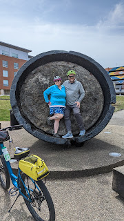
In theory, you could ride from the incline to downtown with only a small section of road travel required, but we chose to drive from the incline to the Three Rivers Trail parking lot beneath the Birmingham Bridge. From there, we rode toward the Hot Metal Bridge, which was once an essential part of the steel industry. Along the path you'll find monuments to the industry, and access points leading to restaurants and shops. The bridge itself is an astonishing structure, a testament to the engineering prowess of previous generations.
Once you're across the bridge, you'll be riding next to and under a busy interstate. This is a noisy, not terribly enjoyable experience. Fortunately, it only takes a few minutes before you're actually downtown. We didn't take many pictures of our effort to navigate the city streets, since we were kind of busy figuring out where, exactly, we were supposed to go. But, there's barely a quarter mile to cover in order to reach Point State Park. The official mile 0 of the GAP is in front of the park's huge fountain. No doubt it would probably have been quite impressive, if it had been running. Fortunately, the truly important waterworks, the public restrooms, were open, operating, and quite clean.
 |
| Even more impressive with water! |
From your vantage point at the fountain, you'll be able to see across the river to stadiums and museums. You can reach these via the Fort Duquesne Bridge. The bridge takes you to an area full of bars and restaurants, and the trail runs for a few miles on both directions on this side of the river. We rode just far enough to get a picture of the submarine docked outside the science center, then took a few photos of the skyline, before grabbing lunch and heading back to our car.
 |
| Going to a mountain town to look at a submarine feels counterintuitive. |
 |
| I don't know anything about sports. I assume this a monument commemorating a guy who threw his hat 406 feet. Impressive! |
 |
| This sign makes the trail look steeper than it really is. |
We still had to drive to the bed and breakfast we'd reserved for the next leg of our trip, and we planned to do a sunset ride once we reached that destination, so we didn't have time to linger. If we do this again, I'd definitely be interested in exploring more of the Three Rivers Trail, and would likely follow the GAP further down the south side of the river. That said, Pittsburg is really its own experience. The rest of the GAP has its own personality, which we'll be talking about in upcoming posts!


No comments:
Post a Comment